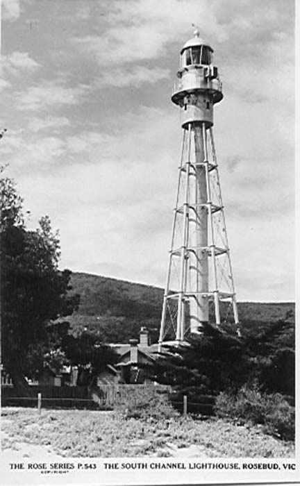
McCrae (Eastern) Lighthouse
The Eastern Shore Light at McCrae guided mariners through the South Channel on the eastern side of Port Phillip Bay for over a 100 years until decommissioned in 1994. McCrae is on the bay side of the Mornington Peninsula.
History
A tall timber skeleton framed structure was the first light established at McCrae. It was later taken in sections by bullock wagon to the top of Arthurs Seat to be used as a lookout. In 1874 Chance Bros. & Co. of Birmingham, England manufactured the present day lighthouse. It was transported to Australia by sea and erected on this site in 1883.
Sometimes known as either the Dromana Lighthouse or the Rosebud Lighthouse, the lighthouse is actually located between both areas at McCrae. It is also known as the South Channel Lighthouse. Measuring 33.5 metres in height it is Victoria’s tallest lighthouse. There are 120 steps up the spiral staircase inside the narrow central turret leading to the lantern room. Here at an elevation of 30.8 metres above sea level the light is visible at a distance of up to 25 kilometres and provides the back mark of the leading navigation line through the main fairway of the South Shipping Channel projecting high intensity white beams along the South Shipping Channel and towards Melbourne, and a red warning sector over the dangerous sandbanks to the North of the South Channel. The electric light was backed up by an acetylene gas standby system which automatically switched into operation in the event of a power failure or fault in the electrical equipment.
One of the unique features of this light is that is has not only dioptric, but also catadioptric and holophotal lens systems.
When in operation the light gave with the South Channel Pile Light a “lights-in-line” channel-centre guidance to inward-bound ships coming up Port Phillip Bay towards Melbourne.
The lighthouse keepers cottages were demolished following automation.
The light was decommissioned by the Port of Melbourne Authority in 1994 following modernisation of Navigational aids in Port Phillip Bay.
It was transferred to the McCrae Foreshore Committee via the Department of Natural Resources and Energy in 1996.
continued below …
| Title | Address | Description |
|---|---|---|
Melbourne Leading Light Rear | 66 Beacon Vista, Port Melbourne VIC 3207, Australia | Melbourne Leading Light Rear |
Melbourne Leading Light Front | Bay Trail, Port Melbourne VIC 3207, Australia | Melbourne Leading Light Front |
Williamstown Timeball | Timeball Tower, Williamstown VIC 3016, Australia | Williamstown Timeball |
Point Gellibrand Pile Light | 31 Battery Rd, Williamstown VIC 3016, Australia | Point Gellibrand Pile Light |
West Channel Pile Light | 75 Bluff Rd, St Leonards VIC 3223, Australia | West Channel Pile Light |
South Channel Pile Light | 2591 Point Nepean Rd, Rye VIC 3941, Australia | South Channel Pile Light |
Eastern (McCrae) | 658 Point Nepean Rd, McCrae VIC 3938, Australia | Eastern (McCrae) |
Cape Schanck | Cape Schanck Access Rd, Cape Schanck VIC 3939, Australia | Cape Schanck |
Shortland Bluff (Black) | 66 Gellibrand St, Queenscliff VIC 3225, Australia | Shortland Bluff (Black) |
Queenscliff (Low) White | 133 Hesse St, Queenscliff VIC 3225, Australia | Queenscliff (Low) White |
Port Phillip Lights | 133 Hesse St, Queenscliff VIC 3225, Australia | Port Phillip Lights |
Point Lonsdale | 9-13 Point Lonsdale Rd, Point Lonsdale VIC 3225, Australia | Point Lonsdale |
continued from above …
More history.
Keepers
We need your help in compiling a list of keepers for this lighthouse. If you have any information then send it to keeper@lighthouses.org.au.
Please include this lighthouse’s name, the keepers full name and what years they were keepers. Also include the same information for any other lights they were on.
Technical Details
| First Exhibited | |
| Permanent Tower | 1883 |
| CurrentTower | 1883 |
| Architect | Chance Bros & Co |
| Status | Decommissioned 1994 |
| Location | Lat: 38° 34.838' S Long: 144° 92.5690' E |
| Original Optic | |
| Current Optic | Chance Bros 3rd order dioptric holophotel |
| Automated | |
| Demanned | |
| Construction | Chance Bros steel lattice tower |
| Height | 33.53 m |
| Elevation | |
| Range | |
| Character Sectors | Occulting 15 sec. (Flash duration 12.5 sec., eclipse 2.5 sec.) White from 81 Degrees through East to 132 Degrees, red to 150 Degrees, white to 205 Degrees, obscured elsewhere. |
| Intensity | |
| Light Source | |
| Power Source | 240v AC Mains |
| Operator | Decactivated, last operator, Ports and Harbours Division, Ministry of Transport. |
| Custodian | McCrae Foreshore Committee |
| Notes | In 1998 the Victorian Government's Department of Natural Resources and Environment undertook significant restoration works to ensure the lighthouse's structural condition. |
NB: Information is historical data and is not for navigational purposes.
Access
The lighthouse is in the Lighthouse Reserve on beach side of the Nepean Highway at McCrae between Dromana and Rosebud.
Though the lighthouse is fenced off there is no restriction of access to the reserve.
Tours
No tours are available.


You must be logged in to post a comment.